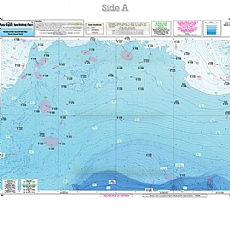
BKL207, Block Island Shelf, Atlantis Canyon, The Dump, Butterfish Holes, Little Fishtails, Ammagansett

SKU: CS-B-BKL207
Weight: 1 lbs
BKL207 Nearshore Bathymetric charts 20 - 30 miles off coast, Side A: Block Island Shelf south of Block Island out to the tip of Atlantis Canyon covering the Dump, the Horn's, Butterfish Holes and Little Fishtails, Side B: Off NY and NJ, covering from Huds
MPN: BKL207
Price: $19.49
BKL207, Block Island Shelf, Atlantis Canyon, The Dump, Butterfish Holes, Little Fishtails, Ammagansett
(Click to see larger image and other views)
Product Details
Captain Segull's Bathymetric Chart BKL207, Nearshore Block Island Shelf - Coastal New York & New Jersey.
Captain Seagull's Charts, maps
Captain Segull's Charts are designed for the serious sport fisherman. All charts are laminated, waterproof and in